August 4, 2019
Mount Yamnuska
Bow Valley Provincial Park, Alberta
Stats as Recorded by Suunto Traverse
Distance : 8.5 km
Elevation : 904m
Ascent : 2h26m
Descent : 2h40m

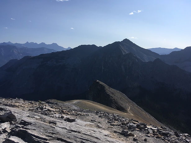
The face of Yamnuska, one of the first mountains you see West of Calgary.
This was fun. I took my fiancee up after having done Yamnuska a year ago. We decided to do it because CTV News had reported Yamnuska was one of the next mountains to be renovated after Ha Ling Peak. Fearing that they'll take away some of the more fun aspects of it (chain section, chimney scramble), I wanted my fiancee to experience it before it all changed (and closed for a year).


It was easy-going heading up to the summit. Veer right at the fork to hike up the hiker's side, which involves some class 3 scrambling moves and the chains. To the left, you can see the steps leading up to the chimney, where rocks have been smoothed by many scramblers and you'll need to mantle for any grip going up. Going up the climber's side minimizes exposure and technical difficulty (which is already minimal), but you'll lengthen the ascent significantly as slogging up scree is never fun. Plus, looping to ski down the scree on your return cuts a lot of time. Or so I thought. It did the first time.
Left photo: The approach of rock steps to the chimney.
Right photo: Over the other side of the chimney. Hopefully you aren't claustrophobic.


Left: Some unnecessary scrambling. Right: The chains section. It is safe, just watch your footing and don't look down.
Heart Mountain (Grant MacEwan peak) can be seen in the background around the corner of Yamnuska's backside.

After topping off at the summit, we hung around for a bit waiting for a discouraged lone hiker to catch up but then descended when he did not top out for another half hour. Follow that first of two long scree runs until you reach the front face of Yamnuska again. Now, this is where it all turned horribly wrong. I followed the same route that I had taken down the first time I summited Yamnuska, bypassing signs of trail closure thinking they were just pre-emptively getting ready for the renovations to Yamnuska. So we
descended down
the "first"
scree run, and
as you can see
from the map
below, we ended
up missing the
actual scree run
just west of us.

We bushwacked through overgrown forest, fallen trees and unfamiliar "trail" for 2 hours.

When we finally broke through the forest to a clearing, this is where we stopped and questioned our choices. "WARNING. NO TRESPASSING. ACTIVE MINE SITE." The thoughts running through my head included: "We are literally a kilometre away from the car. Bushwhacking back and heading up the scree slog will put us probably close to 2 a.m. return, and headlamps and food were in the car. The mosquitoes are eating me alive here. Would we blow up if we walked through the mine site?"
Shoutout to Canmore Search and Rescue for responding to our situation and informing us that the quarry was a minING site, hence not currently active as no one was working at 8:30 p.m. on a Sunday.
Given that go-ahead, we ran through the quarry and back to the car, where we discovered that there is a $5,000 fine for trespassing.


Lesson learned: Do not trust past experiences because trails can change. If you're going on Yamnuska soon and wanting to make the loop, either traverse the along the highest path on the front face of the mountain, or descend via. the second or third scree run (which is what my friend did the day after and she was able to hit the non-overgrown forested trail that joins back with the main trail).