September 14, 2019
Triple Crown (Attempt)
Canmore, Alberta
Stats as Recorded by Suunto Traverse
Lady Mac Distance : 8.9 km
Elevation : 1243m
Ascent : 3h46m
Descent : 2h25m
My fiancée had done the Triple Crown 3 years ago, over the course of 3 days with some friends. I completed it as my second ever hiking trip two years ago, solo, and ran into some hiccups along the way, over the course of 2 days. Not a big fan of repeating hikes, but there were a number of reasons to do this again. Despite the hordes of people on Ha Ling, I still wanted to see how the new renovations changed the trail. As well, with my new goal of 30 summits before I turned 30, I couldn't count Lady Macdonald since I had only gotten to the helipad the first time around due to snow and 0 visibility on the ridge. So we set out from Edmonton at 11 P.M. to see if we could complete the Triple Crown in a day. The plan was to go from hardest to easiest so that we would be more and more motivated, and have daylight for EEOR as we had both gotten lost on that trail before.

On the return from the summit, the scree run was quite fun and took a 1 hour ascent time down to a 15 minute descent time back to the helipad. From here, we began to see other hikers all the way down to the trailhead.
Lady MacDonald: ✓
We drove back to Canmore Save-On-Foods for a washroom break, some sandwich samples at the hot foods station, and a meal at Tim Hortons, before heading onto Spray Lakes Road for EEOR.
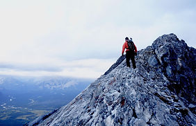
We arrived at the Cougar Creek parking at 3:30 A.M. After changing and packing our bags, we followed the light of our headlamps up along the creek and then into the forest and onto the trail. There were several brief moments where we veered slightly off the trail, but we topped out onto the crest just below the helipad right at sunrise and saw a faint orange glow behind the clouds. The wind started to pick up and after snapping a few pictures at the helipad, we continued onto the ridge toward the summit. Some fun scrambling to be had here, and would have been a lot more enjoyable minus the wind. Staying South on the ridge, on the Canmore side of the mountain, affords better holds and less exposure.

I think it was around 1 P.M. when we started up EEOR. The trail was fairly populated. We paid attention to the blue squares on the ground, knowing that it would be more challenging finding them on the way down. Prior to the meadow, a couple of groups had stopped due to fear/concerns with safety. This has been a big theme for me this year: know your limits, the mountains will still be here another day. After freezing on EEOR (it had started to snow), we snapped our quick summit photo and headed back down, making pretty good time to finish with Ha Ling at the end, before sunset. And then things started to go wrong...

Summit photo at EEOR. Ha Ling, the last objective of the day, is seen to our right below. This picture marks the end of happy times unfortunately. On our way down, we got into an argument, and as you will be able to see by GPS tracks below, got lost because we weren't paying attention to the trail anymore. We bushwhacked and probably spent an extra hour or two longer than required to descend, and some how ended up exiting out the goat creek trail rather than EEOR.
East End of Rundle: ✓
We had the time to finish Ha Ling, but neither of us were in the mood to. The Triple Crown in a day challenge will have to wait until next time, maybe after we get married and when arguments don't phase us anymore.
Stats as Recorded by Suunto Traverse
EEOR Distance : 4.6 km
Elevation : 844m
Ascent : 2h10m
Descent : 2h47m

You can see where we had our argument. We diverted further and further from the trail about halfway down and our descent time slowed down significantly no thanks to emotional and physical frustrations. Thankfully there are multiple trails up and down EEOR, and after a bit of bushwacking, we found our way to the highway and the car again, only with zero motivation to finish the rest of the Triple Crown.
