August 16, 2019
Parker Ridge
Banff National Park, Alberta
Stats as Recorded by Suunto Traverse
Distance : 4.56 km
Elevation : 284m
Ascent : 0h38m
Descent : 0h37m

Squinting as I try to see the mountaineers/campers on the Saskatchewan Glacier
The best effort:reward ratio I've ever experienced on a hike. I was concerned because I did not realize how long it took to drive out to the Columbia Icefields, and I had taken several naps along the highway as well as taken a chunk of time to eat a large buffet before the hike. I got to the trailhead at 8 PM and the sun was scheduled to set at 9:06 PM. I'd read that it would take 2 - 2.5 hours round trip. I decided I did not have time to change and booked it up in my sneakers and work clothes.

As you are heading up the trail, stop to smell the flowers along the way. The vibrant colours dot the foreground as grayscale mountains and overcast skies loom behind. I was running up already but I had to stop for a quick photo. There were two groups headed down the trail as I was on my way up. Trailhead had minimal cars due to the late start, but you can expect many people earlier on in the day as it is one of Banff's most popular hikes. The sunset was partially blocked by the mountains, and I would assume that this would be better suited as a sunrise hike if you are looking for peace and quiet on the trail.
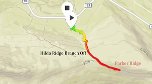
Just over halfway up you will come to a large clearing and a faint path that veers off to your right. I am looking back at it on the return in this photo. If you turn right, you will be headed toward the smaller glacier that you would have seen at the beginning of the hike while driving up. This is Hilda Glacier, and you would be approaching via Hilda Ridge. My goal was to see the Saskatchewan Glacier as it is much more grand, but if I had the time, I would definitely have done the side-trip as well, given the relaxed pacing of this hike.
Maintain on the wide pebble path towards the left, where it will eventually narrow out to Parker Ridge and the lookout point for the Saskatchewan Glacier will soon follow. Continue to follow the yellow diamond markers on cairns and signs which dot the trail.


Rare that a trail has a fixed "end point". Continuing past is a faint scree path which eventually stops. This is an out-and-back trail so your turn around point would be here, but not before soaking in the views. A higher vantage point is to your left when looking at the sign, with large shale and boulders to climb up, but it would not provide a significant improvement in the view and you may damage the beautiful trail by sending rock down onto it.
Many signs on the trail deter from its beauty reminding people to stay on trail as restoration is in progress, and please follow the signs because short-cutting will not save you a significant amount of time, and these alpine meadows take years and years to grow to this point. After paying your respect to the land and retreating glacier, return the way you came.
We bushwacked through overgrown forest, fallen trees and unfamiliar "trail" for 2 hours.

This alpine moss has been growing for a hundred years, and the glacier has been retreating even longer.
Make sure you explore before it is too late!